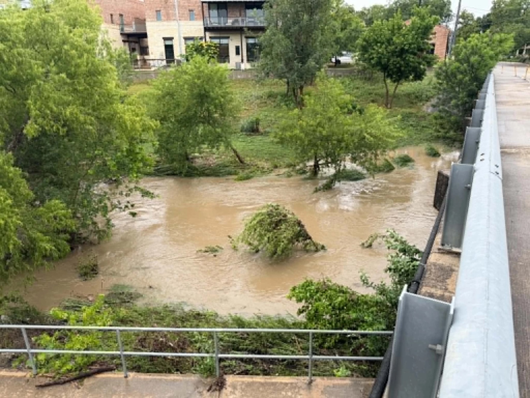
Heavy rain swept across the San Antonio area Monday morning, triggering flood warnings, road closures and disruptions to summer school programs as forecasters warned additional rounds of showers and thunderstorms could bring more flooding through Tuesday evening.
Read more How some San Antonio students go straight out of high school and into the fire station
A Flash Flood Warning was issued for parts of the San Antonio metro area through the Monday morning commute as heavy rain moved south from the Hill Country. A broader Flood Watch remains in effect for San Antonio and much of South Central Texas through 7 p.m. Tuesday.
The Flood Watch includes Bexar, Comal, Guadalupe, Hays, Kendall, Kerr, Bandera, Medina, Wilson, Atascosa, Caldwell, Bastrop, Travis and Williamson counties, as well as much of the Hill Country and Interstate 35 corridor.
The National Weather Service said very humid tropical air interacting with a stalled frontal boundary will continue to support showers and thunderstorms capable of producing heavy rainfall. While widespread rainfall totals of 1 to 3 inches are expected, isolated areas could receive significantly higher amounts where storms repeatedly move over the same locations.
Rainfall rates could exceed 2 to 3 inches per hour in stronger storms, creating a risk of flash flooding, especially in low-lying and flood-prone areas.
The storms also disrupted summer school programs and other activities across the region. Harlandale ISD, South San Antonio ISD and the Alamo Colleges District delayed operations Monday morning, while Bandera ISD canceled summer school classes. Judson ISD canceled athletic camps, practices and events, and Cibolo-Schertz-Universal City ISD canceled summer learning programs and camps because of flooding concerns and hazardous travel conditions.
Excessive runoff could cause flooding along rivers, creeks and streams, as well as at low-water crossings and other flood-prone locations. Drivers are urged never to attempt to cross flooded roadways.
City officials are urging residents to use caution while traveling during periods of heavy rain.
San Antonio’s most flood-prone low-water crossings include Old Seguin Road at Salado Creek, Old O’Connor Road north of Lookout Road, Pinn Road and Gibbs Sprawl Road at Rosillo Creek.
Residents can find current conditions and road closures at low-water crossings throughout the county here.
Read more Proposed ban on Big Bend border wall fails in U.S. House funding panel
Showers and thunderstorms are expected to continue through Monday afternoon, with some storms capable of producing an additional 1 to 2 inches of rainfall.
Additional rounds of showers and thunderstorms are expected Monday night into Tuesday, prolonging the risk of flooding across the region before conditions gradually improve later Tuesday.
Monday’s high temperature is expected to reach about 82 degrees under mostly cloudy skies. Rain chances continue Monday night, with a low near 74 degrees.
On Tuesday, forecasters expect a 50% chance of showers and thunderstorms, mainly before late afternoon, with a high near 85 degrees. Additional rainfall of one-half to three-quarters of an inch is possible. Rain chances diminish Tuesday evening, though isolated showers may linger.
Conditions are expected to improve beginning Wednesday, when mostly sunny skies return and temperatures climb to around 90 degrees.
The warming trend continues later in the week, with highs reaching the mid-90s by Thursday.
Rain chances return late Thursday night, with a slight chance of showers and thunderstorms after 1 a.m. More widespread rain chances arrive on Juneteenth, when forecasters expect a 50% chance of showers and thunderstorms. Additional opportunities for rain are expected through the weekend.
Residents are encouraged to monitor the latest forecasts, keep weather alerts enabled on their phones and remain alert for possible Flood Warnings as conditions evolve.
Read more Pay raises at Northside ISD could be contingent on voter approval
This story first appeared at Texas Public Radio.